How to Conserve Wildlife Migrations in the American West
Overview
The natural spectacle of wildlife migration has beguiled people for millennia—a sense of wonder that continues today. Aristotle and his contemporaries marveled at the sudden disappearance of birds and animals in the fall and their reappearance in spring.1 Now, in the 21st century, science is uncovering fascinating new information about the amazing treks that mule deer, elk, and pronghorn make each year across the American West.
Every day, from some of the most remote and spectacular reaches of the United States, special GPS collars affixed to large ungulates (hoofed mammals), other mammals, and birds beam tens of thousands of electronic signals via satellite to researchers across the country. This information, which primarily indicates where a particular animal is located at a given moment, is revolutionizing the understanding of wildlife ecology by enabling scientists for the first time to pinpoint when and where wildlife moves at a grand scale.
The massive amount of data generated from these research endeavors is also transforming the work of wildlife managers, land stewards, transportation officials, and policymakers. In addition to answering simple questions about where animals go every spring or fall during their migration seasons, the data is providing critical new insights into why and how animals move between seasonal ranges. Although GPS has been around for several decades, it has only recently been scaled up for broad applications in wildlife research. And as the data pours in, that new knowledge has significant implications for how wildlife and their habitats can be managed to ensure that migrating species can persist and thrive in the face of old and new challenges.
This report is based on a synthesis, conducted by the Wyoming Migration Initiative on behalf of The Pew Charitable Trusts, of the growing body of science regarding the migration of western North America’s populations of mule deer, elk, pronghorn, and other ungulate species and identifies the most substantive threats to migrating wildlife. The key findings are:
- Migration between seasonal habitats is a critical part of the life cycle of most ungulate populations in the western U.S. Moving from place to place, often across hundreds of miles, allows these animals to negotiate changes in weather, food availability, predator activity, and other ecological variables. Ungulates that migrate successfully tend to be fatter than those that do not, and fatter females are more likely to survive the winter and produce healthier young, which in turn supports the overall well-being of herds.
- When migration pathways are blocked or disrupted, animal populations tend to decline. Wildlife depends on resources that are found in different places throughout the year, and when animals cannot access food or important habitat, individual animals and the herd can suffer. Further, because animals in some species learn how and where to migrate from older members of the herd, disturbance of a route for more than a generation can mean the long-term or permanent loss of that inherited knowledge and, with it, vital nutritional and fitness resources.
- Human activity disrupts migratory behavior and jeopardizes the health of ungulate populations. Fencing, roadways, residential development, and energy and mineral production operations can block, alter, or fragment migration routes and limit access to adjacent habitat that ungulates rely on. And climate change is altering the growth patterns and abundance of forage at key locations and times of year. Additionally, wildlife-vehicle collisions on our nation’s roads take a costly and sometimes deadly toll on animals and people, while entanglement in fences claims hundreds of animals’ lives each year.
In light of these findings, The Pew Charitable Trusts has developed a set of broad recommendations to help land and wildlife managers, conservationists, industry, and other stakeholders better coordinate and direct their efforts to protect these majestic species:
- Increase mapping and research efforts. Core research focused on better understanding where migrations occur, how widespread they are, and what challenges and threats migrating ungulates face is the first step to conserving wildlife. More such research is needed from academia; Tribal governments; and state, federal, and nongovernmental stakeholders.
- Identify and coordinate with human stakeholders whose activities intersect with wildlife migration routes. Most migrating animals cross property boundaries at some point in their travels. Better alignment of land use rules and priorities among landowners and managers is essential to conserving the wildlife that transits public, Tribal, and private lands.
- Remove or modify fences in key migration corridors. Fences are ubiquitous features in the U.S. West and present challenges to wildlife along migration routes. Fences that no longer serve a purpose can be removed, and fences that are still in use can be retrofitted to wildlife-friendly specifications. In addition, new “virtual fence” technology that uses GPS to contain livestock while allowing wildlife to pass unrestricted is gaining in popularity and functionality, offering the potential for a future of safer, more open landscapes.
- Build wildlife-crossing structures along roads and highways. Millions of large animals die every year in the U.S. from collisions with vehicles. The cost to humans is also significant, with tens of thousands of motorists injured annually. Wildlife bridges and underpasses are highly effective at reducing these crashes, improving safety for animals and humans alike. They also facilitate essential wildlife movement, making herds more resilient in the face of drought and other changes in their habitat.
- Provide conservation easements or other incentives to landowners. The development of private land that intersects migration habitat can have long-term detrimental effects on migrating wildlife. Incentives that encourage landowners to keep land free of structures, industrial or commercial activity, fencing, and other barriers are a key strategy for conserving migration corridors.
- Practice smart energy and mineral development on federal lands. Oil and gas leasing, mining, and renewable energy development carried out on known migration routes can harm migrating wildlife. Siting extractive development operations away from migration corridors—or at least minimizing their density within those corridors—would support animals’ ability to use important routes and access key forage opportunities.
- Engage in local and regional land use planning. Especially in exurban areas where residential neighborhoods are encroaching on wildlife habitat, county, city, Tribal, or federal land use plans can help identify important areas such as migration corridors and put protective zoning restrictions or other conservation overlays in place as the human footprint increases in these areas.
This report details the current state of knowledge about the many long migrations in western states—and how to conserve this compelling and vital process for the health of ungulate species, the diverse habitats they transit, and the character of the American West.
The science of ungulate migration
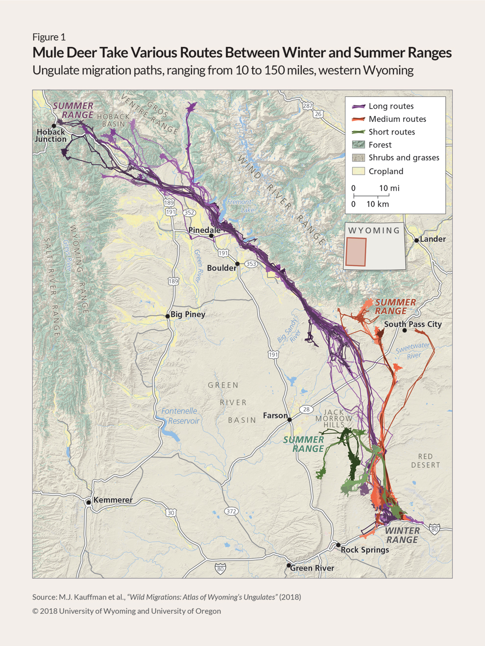
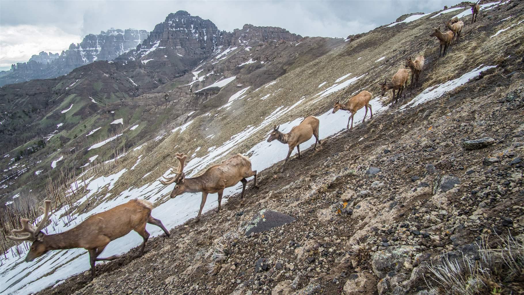
Migration is the annual back-and-forth movement of animals between seasonal ranges. (See Figure 1.) In the western U.S., mule deer, elk, pronghorn, moose, and bighorn sheep spend their summers at high elevations eating green vegetation, which fuels the creation of body fat necessary to survive the lean winter months.2
When the snow begins to fall in autumn, these animals slowly move down to their wintering grounds at lower, warmer altitudes. And as the first green buds emerge the following spring, they begin this roundabout journey again, following the spring green-up up the mountainsides.
Ungulates give birth in late spring and early summer, after they have had a chance to replenish some of their depleted winter fat reserves and can provide the best nutrition for their young.3
Why migrate?
Ungulates migrate for several reasons: seeking out abundant forage, avoiding inhospitable areas, and distancing themselves from predators and parasites.4 For ungulates in the western U.S., migration is the solution to the seasonal fluctuations in weather and food availability across the region’s many mountains and valleys.
For example, the peaks of the Rocky Mountains can receive up to 50 inches of precipitation a year, which in turn supports abundant grasses, forbs, and shrubs, but they also retain deep snow for many months, which makes them inhospitable in winter. And although the valley floors get only about a tenth of the precipitation that the peaks receive and so have a lower abundance of forage, they provide winter refuge from the deep snows and harsh temperatures of the mountains. Migrating between the mountains and valleys in concert with the seasons allows these animals to access the best food with the least effort throughout the year.
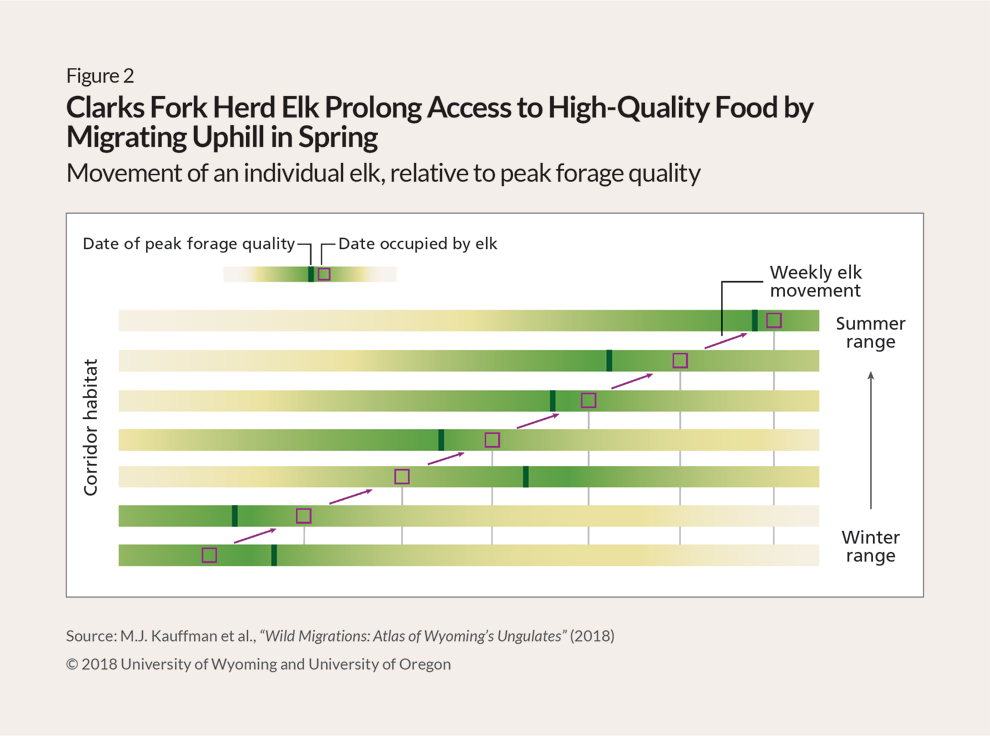
Yet the benefits of migration do not end with simply getting animals to the right range at the right time of year. Recent research indicates that the migration routes themselves, and the time at which animals move through them, also provide substantial benefits. For instance, as all gardeners know, lettuce and other greens taste best when harvested young. Ungulates, which are primarily herbivores, also know this, and it is critical to their diet and nutrition. Foraging ungulates seek out plants in their earliest growth stages, when nutrient-dense plant parts are at their peak relative to indigestible parts, such as stems.5 And although gardeners can control when their plants will be ready to harvest, ungulates must move around the landscape to find plants at peak forage quality.6
Because temperature is moderated by elevation, the start of the growing season arrives later as the altitude increases. This creates a “green wave” in which spring conditions slowly propagate upward and from south- to north-facing slopes throughout the spring months.7 For example, in the Rocky Mountains, the green-up date extends five days for every 300 feet of additional elevation.8
Ungulates capitalize on this phenomenon by timing the start of their migration with the onset of spring, when plants are at their earliest growth stages, and “surfing the green wave” uphill over the course of spring and early summer.9 (See Figure 2.) Although ungulates could complete their migrations in a matter of days, they take their time. Mule deer, for example, can spend up to three months migrating, maximizing their exposure to early spring conditions that provide high-quality forage along the way.10
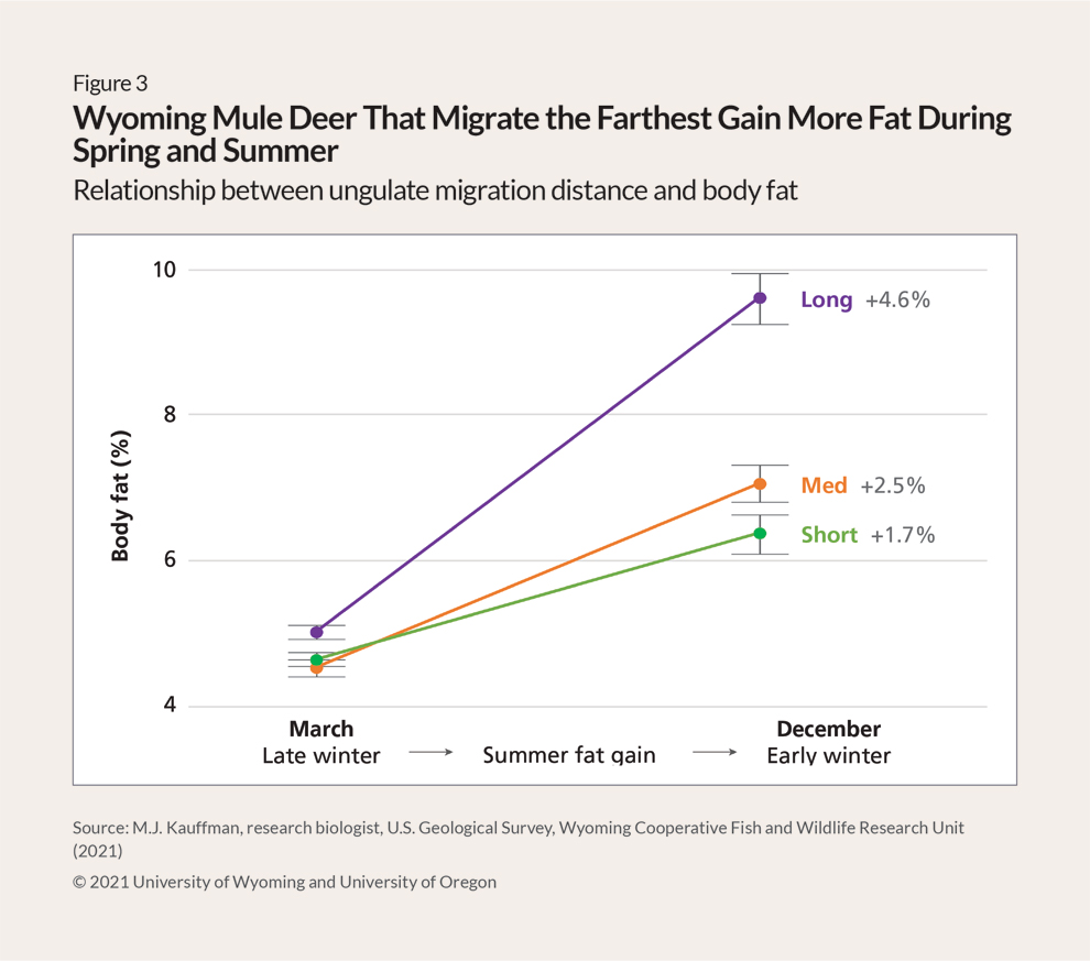
Animals that move in near-perfect concert with the green wave end up fatter at the end of the summer than their counterparts that surf the wave less well or stay in one place year-round.11 In North American female ungulates, autumn fat levels are clearly linked to the probability of getting pregnant, surviving the winter, and giving birth in the spring, which suggests that effective green-wave surfing plays a role in bolstering migratory populations.12 (See Figure 3.) The ability of migratory ungulates to move freely and exploit forage at specific times of the year is critical to their success and is one of the reasons for their abundance in the West and on the planet.13
When to migrate?
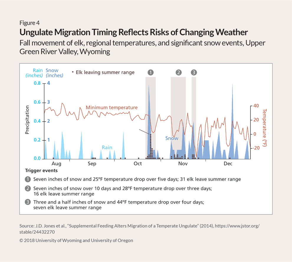
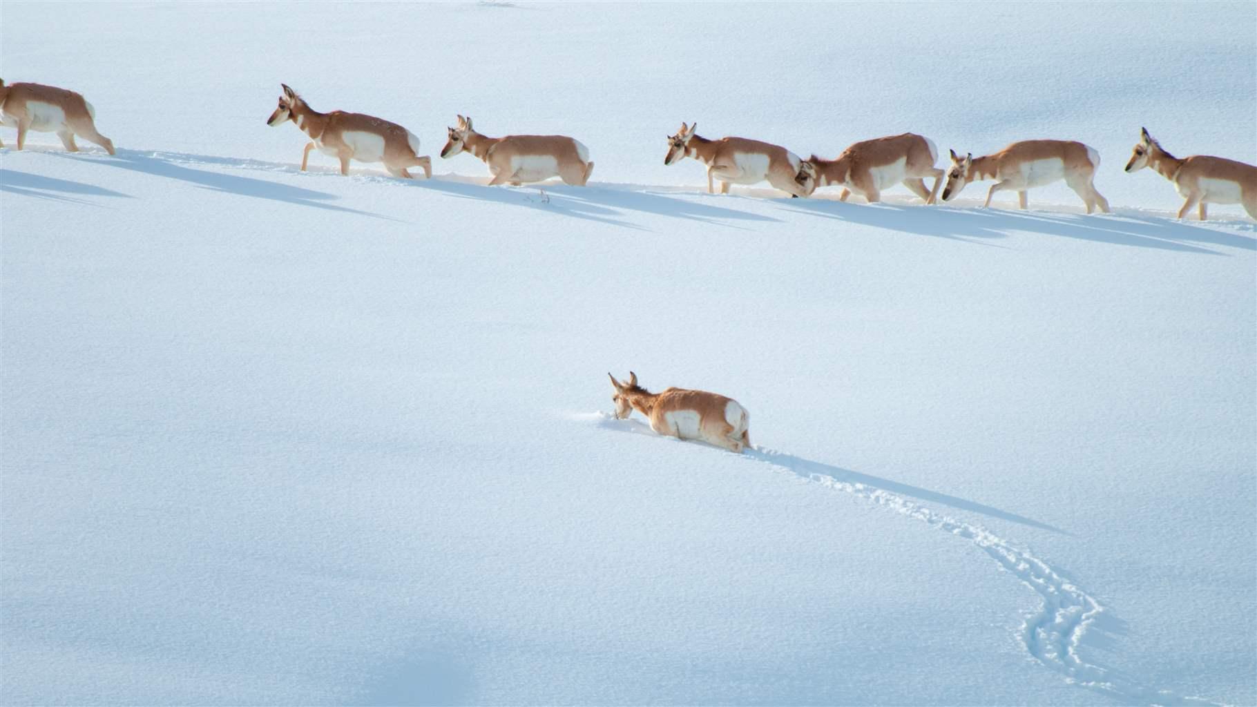
Although seeking out the best forage is important, ungulates must also minimize the costs of moving. (See Figure 4.) One substantial hazard they face in the western U.S. is snow, which not only buries forage, forcing animals to dig for their food, but also increases their costs of movement—the energy they must expend while traveling—and their vulnerability to predation.14 In most cases, animals incur significant costs only when they encounter snow at a depth that requires excessive exertion to traverse. These snow thresholds vary by species based on hoof size, chest height, and the mechanics of their legs.15 For example, mule deer are particularly sensitive to snow depths of more than 1.5 feet, but moose have a much higher tolerance because they have relatively long legs with special shoulder joints that allow them to lift their hooves up and out of the snow.16
But snow levels are just one of a suite of environmental characteristics that trigger ungulates’ spring migration. When an animal starts its end-of-winter journey and how fast it travels are key to its ability to successfully exploit the best forage and reduce the costs of moving in deep snow.17 For mule deer in the Sierra Nevada Range of California, the start of spring migration correlates with snow depth but is also associated with the onset of plant green-up on the winter range.18 And for elk in the Greater Yellowstone Ecosystem (GYE), it correlates with the timing of snow melt on winter range and green-up along migration routes, as well as winter range productivity and migration distance.19
Similarly, in fall, ungulates must balance several factors, including the benefits of staying on summer range longer to continue foraging versus the risk of getting caught in deep snow on the way to lower elevations. Research shows that although capitalizing on bits of green-up in the autumn results in larger-bodied mule deer fawns, early winter snowfall decreases fawn survival rates.20 Animals typically begin heading to lower elevations when temperatures drop and snow begins to fly, with the species that are most sensitive to snow, such as pronghorn, leaving their summer ranges first.21
For mule deer in the Sierra Nevada, the start of fall migration correlates with snow depth, mean daily temperature, daily snowfall, and change in daily temperature, but less so with the timing of forage decline.22 By contrast, the start of the fall migration among elk in the GYE correlates with the first snowfall on the summer range and increased exposure to hunting pressure, as well as summer range elevation and migration distance.23 Changes in the availability of forage on agricultural fields or in supplemental feeding—when wildlife managers place hay near wintering herds—can also influence the timing of migration and whether individual animals migrate at all.24
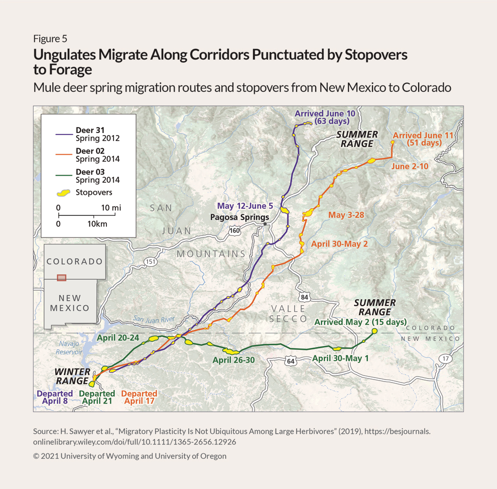
Yet, whether in spring or fall, once ungulates start migrating, the time they spend en route varies greatly. Some herds and species migrate in just a couple of days, while others travel for weeks or months.25 For instance, mule deer migrate on average approximately 0.5 to 1.5 miles a day in western Wyoming, but these average movements can be broken up into bouts of rapid movement, punctuated by days spent in a single area.26 These two modes can be classified as “fast directed movements within corridors” and “slow circular movements within stopovers.” (See Figure 5.)
Stopover behavior is well known in birds, which use stopovers to rest, refuel, and accelerate their migration to breeding grounds.27 Ungulates, on the other hand, use stopovers as foraging sites and to slow down and keep pace with the maturation of forage plants.28 Mule deer in Wyoming, for example, spend 95% of their migrations on stopovers where forage quality is higher compared with movement corridors.29
Whether to migrate?
Unsurprisingly, given the vast distances and variable topography that ungulates must navigate during their journeys, their migratory behavior is highly complex. Each year, individual animals must choose which route to take, which summer range to go to, which individuals to migrate with, and, in some cases, whether to migrate at all.30
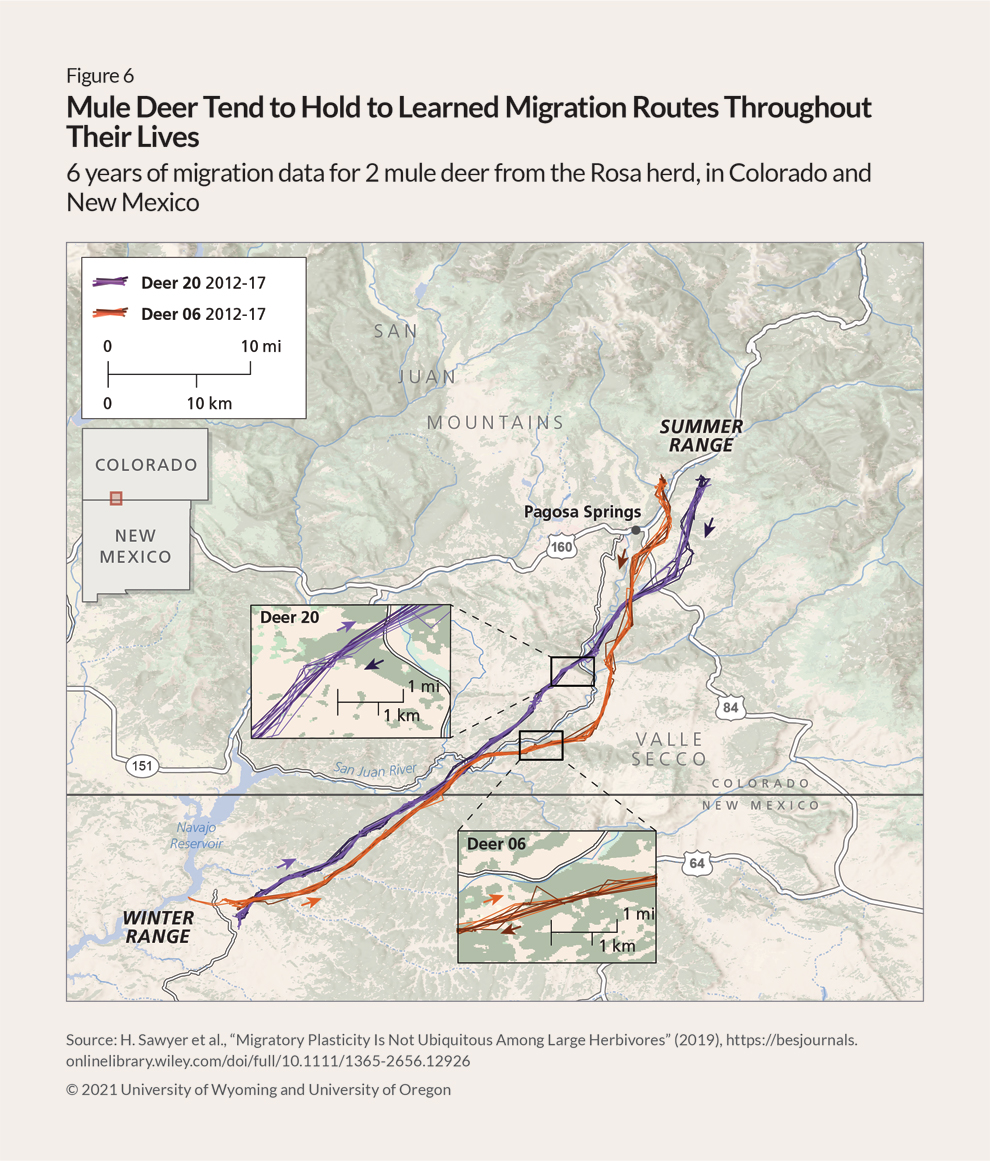
Deciding whether to migrate is the first choice they must make. Ungulates fall along a spectrum in this regard. Some species and populations, notably pronghorn, switch frequently between migration and residency—that is, remaining in one area year-round.31 Others switch more occasionally. For instance, approximately 15% of one elk herd in Alberta, Canada, switches between migration and residency in any given year.32 And some populations— such as mule deer of the Rosa herd, which migrate between the Navajo Reservoir in New Mexico and Pagosa
Springs, Colorado—never seem to switch.33 Further, a synthesis of data from more than 300 mule deer in Colorado, New Mexico, and Wyoming that were monitored for two to six years found that animals that were resident at the start of monitoring remained resident and those that were initially migrants stayed migratory.34
Switching behavior has been linked to population density, predator abundance, winter severity, and the amount of precipitation on summer range, and to characteristics of individual animals, such as age.35 Similar predictors of the choice to migrate have also been found in other ungulates around the world, such as wildebeest, red deer, and moose.36 Notably, a recent meta-analysis of various populations and landscapes across the globe found that ungulates were more likely to exhibit a migratory strategy in settings where the green wave phenomenon is more pronounced, as is the case in many landscapes of the American West.37
Where to migrate?
If migration is chosen, the next decision is which route to take. Ungulates have strong spatial memory—they can remember places they have been to in the past and efficiently return to them—which is an essential ingredient for successful navigation during migration.38 For example, an analysis of mule deer found that the location of their summer range and the migration path they used the previous year were much stronger predictors of animals’ migratory movements than key habitat variables, such as forage quality, snow depth, and topography.39 (See Figure 6.) This means that following the green wave or seeking out specific habitats alone are not sufficient to drive migration route choices. Rather, an individual or herd’s memory of their migration routes largely informs their movements.
However, knowledge of a particular migration route requires learning it in the first place. Ungulate biologists have long speculated that migratory behavior is passed down from mother to young.40 And evidence increasingly indicates that ungulates not only can rapidly learn the location of movement paths but also rarely forget them once learned.41 A recent analysis of movement data from multiple populations of reintroduced and translocated bighorn sheep and moose strongly supports the idea that migratory behavior is developed through social learning, probably from mother to young: Very few of the reintroduced animals migrated after their release, but each population developed migratory behavior over the course of generations.42
Although learning a migration route as a juvenile is key, adult animals may still make small adjustments to their routes or learn entirely new ones based on whom they migrate with. Many ungulates are gregarious and migrate in groups. And for those groups to remain together during migration, the animals must agree on when and where to go.43 Further, interactions among individuals can provide an animal with new knowledge related to foraging sites and migration routes.44 For instance, among bison, joining a group with a home range different from one’s own increases an individual animal’s chance of visiting and learning about new areas.45 Yet because some ungulates, including moose, migrate alone and others, such as elk, migrate in groups of a hundred or more, the role of learning in migration behavior and success varies greatly among big game in the West.
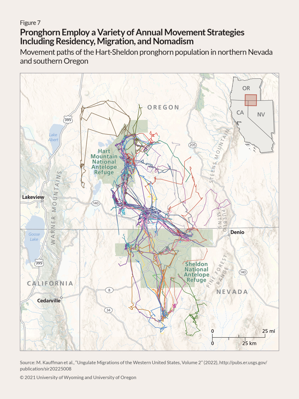
In addition, the migratory behavior of some animals can be unpredictable and occur outside typical spring and fall seasons. For example, pronghorn in northern Montana, southern Alberta and Saskatchewan, and the Greater Hart-Sheldon area of Oregon and Nevada may migrate, or they may engage in nomadism: diffuse, irregular movements that rarely overlap.46 (See Figure 7.) Other examples include elk that repeatedly move back and forth between winter and summer ranges during fall and other ungulates whose migrations feature significant elevation changes over relatively short distances and that similarly move between ranges multiple times throughout the year.47 These variations illustrate the diversity of factors that influence ungulate migrations and the movement strategies they employ in response to those many variables.
Effects of migration on ecosystems and the economy
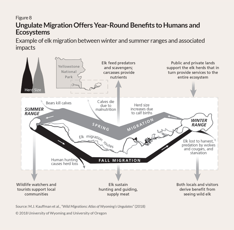
Seasonal movements of ungulates provide more than just a boon to these species’ own population numbers. Migration promotes abundance in herds, which in turn provides a range of critical ecosystem services: natural processes and products that benefit people. And the ability of migratory ungulates to move between seasonal ranges cascades through the food web and underpins other ecosystem processes.48 (See Figure 8.)
As prey animals, migratory ungulates provide food for carnivores, scavengers, and omnivores, while as consumers, they influence plant abundance, quality, and life cycles.49 Further, ungulates often forage in one place and defecate in another, facilitating plant dispersal and establishment as well as nutrient cycling.50 And ungulate movements enable the spread of disease in some cases but help snuff it out in others.51 Taken together, these observations make clear that migratory ungulates play a key role in the functioning of the broader ecosystem.
Humans also capitalize on migratory ungulates. These animals have been a mainstay of North American Indigenous peoples’ food, clothing, and cultural practices for thousands of years.52 And today across the western U.S., abundant herds support hunting and ecotourism industries that contribute about $1 billion annually to the national economy.53
Detailed evaluations of the modern economic impact of ungulate migrations are scarce. But one analysis of 2015 data from Wyoming found that the state’s big game species, most of which are migratory, support $224 million in retail sales, have a total economic impact of more than $303 million, and support at least 3,100 jobs, mainly guides who host out-of-state hunters.54 And hunting and outfitting provide sizable economic benefits to other western states. For example, during 2014, elk hunters spent $138 million on food, lodging, transportation, and equipment in Montana.55
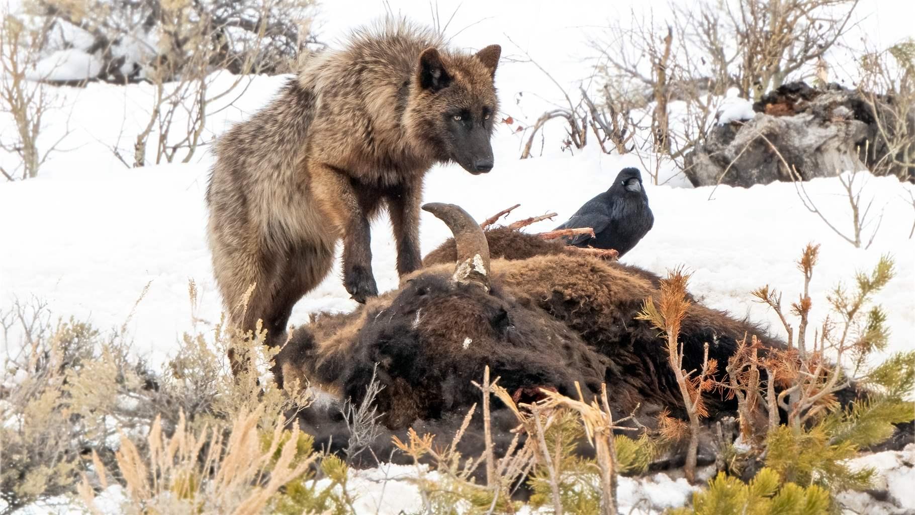
Further, in spring, elk give birth, and as the herds migrate from winter ranges into Yellowstone National Park, those calves feed the wolves and grizzly bears that are a main draw of tourists to Yellowstone and fuel a robust tourism economy in the surrounding communities. In one recent survey, over 70% of the more than 3 million visitors to the park indicated that they came to see wildlife, especially predators, noting that “viewing wildlife in their natural habitat” was an “extremely” or “very” important motivation for their trip.56
Challenges and threats to migratory species
Migration ecology is a rapidly advancing field. Much more is known about migratory ungulates today than just a decade ago. For example, researchers now quickly and easily collect fine-scale data to reveal migratory patterns; understand how green-up influences migration; recognize that migratory behaviors can be flexible but may vary among individuals and species; are starting to grasp the role that disease can play in affected populations; and have sophisticated maps and infographics that allow migration to be considered in land use planning.57 Yet, despite these advances, the conservation of migratory ungulates remains a daunting challenge as landscapes and the climate change at unprecedented rates.58 Furthermore, ungulates require large and relatively undisturbed landscapes with long distances between seasonal habitat patches, which often means they must move across many jurisdictional boundaries. These extraordinary space and distance requirements make ungulates in the western U.S. and around the world especially susceptible to threats such as habitat fragmentation and loss, mainly related to roads, residential growth, and energy and mineral development; other human activities; disease; and environmental changes.59
Habitat fragmentation and loss
Nearly all the world’s wildlife now lives in environments that have been altered in some way by humans.60 In the American West, conversion of land to commercial, industrial, or residential uses is increasing rapidly as the human population in the region grows faster than the national average. The effects of these changes on wildlife habitat fall broadly into two categories, fragmentation and loss, each of which contributes to the other and strongly influences migratory species’ distribution and viability.61
Fragmentation, or breaking apart, of habitat may have positive or negative effects on wildlife.62 For example, fires may disrupt and fracture habitat in ways that benefit migratory ungulates by spurring new plant growth, and some agricultural development may provide new food sources in the form of tasty crops such as alfalfa that benefit ungulate populations.63 For seasonal migrations, however, fragmentation is generally detrimental, blocking movements, limiting access to critical habitats, and increasing the risk of injury and death.
Similarly, habitat loss, as its name suggests, is the destruction or removal of habitat. More so than habitat fragmentation, habitat loss has persistent negative effects. Although any single instance of habitat loss rarely causes meaningful harm, the cumulative loss from multiple human activities adds up to significant acreage and restricts ungulate movements.64
The physical footprint of human activities that eliminate or carve up valuable wildlife habitat is plain to see throughout the western U.S.65 Less obvious and more complex, however, are the behavioral and physiological responses of wildlife to the resulting changes in their environments, migration routes, and ranges.66
For example, mule deer tend to move more quickly through altered areas, which allows them to minimize their exposure to the disturbance but can also reduce the amount of stopover habitat that they use.67 In such cases, movement is maintained between seasonal ranges, but the functionality of the migration route is compromised because removal or reduced use of stopover habitat impedes an animal’s ability to surf the green wave and maximize nutritional intake.68
However, such behavioral effects during migration may not become evident until after a certain threshold of disruption is exceeded, at which point they become more difficult to address or reverse.69 And those thresholds are difficult to detect and may vary with the type of human activity, habitat, and species involved.70 Nevertheless, understanding the major human activities that affect wildlife in the American West and how key species respond can begin to reveal possible solutions.
Roads
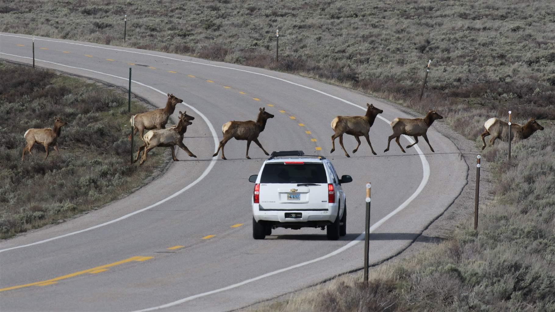
As animals traverse roads during seasonal migrations and at other times of the year, the resulting wildlife-vehicle collisions present substantial hazards and costs for motorists, including roughly 200 human deaths, 29,000 animal injuries, and the deaths of an estimated 1 million to 2 million large mammals, mostly deer, in the U.S each year.71 That adds up to a cost to American drivers, businesses, and taxpayers of $6 billion to $12 billion annually.72 And the number of these collisions is only expected to increase as traffic volume rises and more roads are built.73
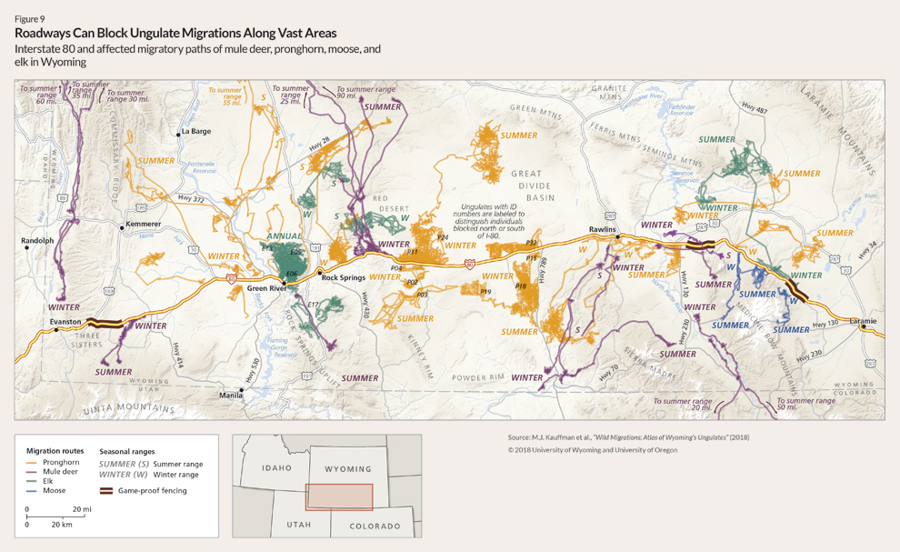
Roadways can also obstruct migratory routes across large regions.74 Interstate 80, for example, extends more than 400 miles across southern Wyoming, blocking the movements and migrations of mule deer, elk, pronghorn, and moose.75 (See Figure 9.)
Fences
Although they have been less studied than roads, fences often outnumber roads in linear feet and represent one of the most prevalent human-made features on the landscape.76 An estimated 620,000 miles of fencing crisscrosses the western U.S., much of it in wildlife habitat away from population centers.77
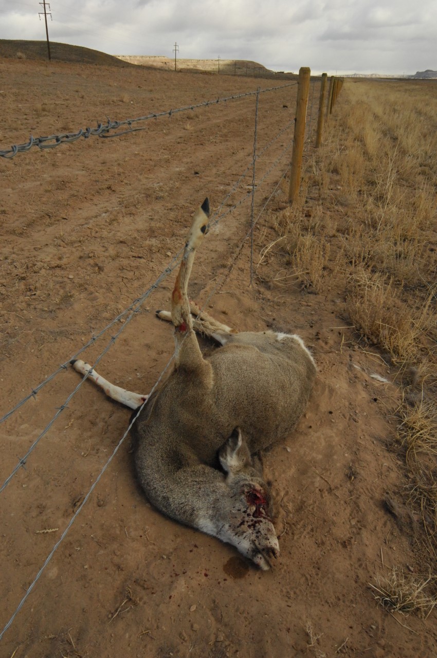
Although fences can provide some benefit to wildlife by keeping animals off roadways, assisting with sensitive species recovery, and maintaining working ranches, more often they are a cause of injury and death for ungulates and, like roads, act as barriers that restrict or limit animal movements.78 Wild ungulates may cross dozens of fences in a single migration. Fences higher than 4 feet are problematic for animals that jump over, and those with low bottom wires or woven wire, or fences partially buried in snow, are challenging for others such as pronghorn, which prefer to crawl under.79 Many animals have scars from barbed wire cutting them. Migrating ungulates also tangle in wire fences, become trapped, and slowly die.80
The magnitude of these effects may vary with fence type and species. In general, however, fences with high top wires and low bottom wires and those with woven wire tend to be more problematic for wildlife than fences that allow animals to move underneath or jump over.81
New research shows that ungulates’ behavioral responses to fences can be complex. These behaviors take three main forms: “tracing,” in which animals move long distances parallel to fence lines; “bouncing,” in which animals move close to fences and then retreat away; and “restricted movements,” in which animals become trapped.82 These responses, in turn, probably have other effects on ungulate movement and distribution, such as restricting access to key habitat at particular times of the year, but those secondary effects are more difficult to document.
Residential, commercial, and industrial development
Residential development is one of the most common sources of habitat loss.83 In places such as the Front Range of Colorado; the Reno, Nevada, area; the Boise, Idaho, region; and the Gallatin River Valley in Montana, rapid growth and development over the past decade have consumed large tracts of previously undeveloped wildlife habitat. And that growth is continuing: The latest U.S. census found that some of the fastest-growing counties are still in those Intermountain West areas.84
Because people tend to settle in valleys and foothills, residential development often conflicts with ungulates’ prime winter habitat.85 To the extent that ungulates avoid or rush through residential areas, they may be missing out on places with less snow, more warmth, and better forage, which can affect the quality and quantity of nutrition they consume in those crucial winter months.86
Energy and mineral development
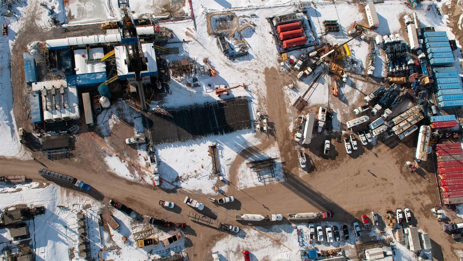
Demand for and consumption of energy (e.g., natural gas, oil, wind, and solar) and minerals (e.g., gold, trona, and uranium) is increasing along with the growing human population and footprint, leading to rapid expansion of extraction facilities across the West. For instance, central North America adds more than 50,000 new oil and gas wells each year, and an estimated 77,000 square miles of additional land in the U.S. will be directly affected by energy development by 2040.87
From a conservation perspective, such development presents a serious challenge, because much of it overlaps with ungulate habitat.88 This is especially true for species such as pronghorn and mule deer that occupy open basins, grasslands, and shrublands where energy and mineral development tend to be more feasible.89
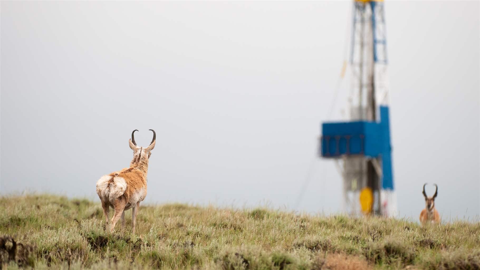
The two main consequences of energy and mineral development are direct habitat loss—such as the building of 6-to-8-foot-tall security fences around a utility-scale solar development project, which preclude ungulates from accessing or moving through the areas—and indirect habitat loss, in which animals avoid a location.90 Such avoidance behavior can be long term, can extend for years, and is especially problematic because it displaces animals away from habitat that would otherwise be usable, effectively reducing the amount of functional habitat.91 Such indirect habitat loss is much larger—in some cases up to 4.6 times—than the habitat lost directly and has been linked to population declines.92
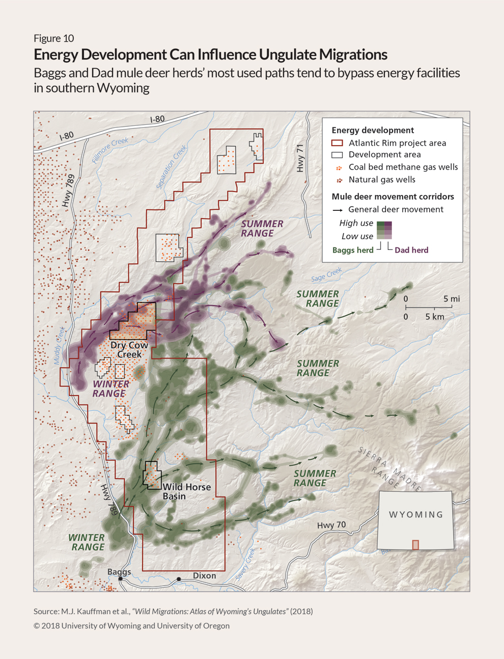
Avoidance is often the primary form of habitat loss related to oil and gas development and can reduce foraging opportunities or cause other behavioral changes that harm animal health.93 For instance, one study observed that between moderate and intensive phases of a Wyoming natural gas field development project, deer use of stopover habitat decreased by 60%.94 (See Figure 10.)
Hardrock mining activity, such as the exploration and removal of earth in search of copper, gold, or rare earth minerals, also tends to result in direct loss. Habitat changes from these activities are usually concentrated and intensified with 100% removal of vegetation and topsoil, whether in the area being mined or where the debris is placed. These effects, combined with security fencing, make mines largely or entirely inaccessible to ungulates for any portion of their daily or seasonal needs, with large mining operations consuming tens of thousands of acres of former habitat.95
Ultimately, when energy or mineral facilities are constructed in crucial habitat, most animals exhibit some behavior changes, but the nature and extent of those behavioral responses can vary by species, geography, and type of development.96 For example, the level of avoidance is lower in regions where rugged topography or vegetation provides refuge from human activity than in open landscapes, such as basins and grasslands, and behavioral responses to wind development are less clear than those related to oil and gas.97
Recreation
Another growing concern among land and wildlife managers is the booming outdoor recreation industry.98 Mountain biking; use of e-bikes, all-terrain vehicles, and motorcycles; backcountry skiing and snowmobiling; mountain climbing; dispersed camping; and other activities are growing in popularity. Existing trail systems are receiving more use, and new trail systems are quickly expanding into areas that historically had low levels of human use. And the potential impacts on migratory animals of these growing recreational demands on public lands, including possible displacement, increased energy expenditures, and lower rates of reproduction, are not yet well understood.99
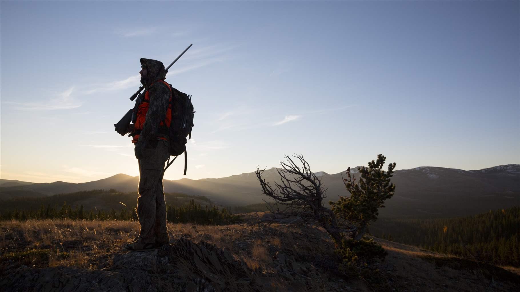
Similarly, the potential impacts of hunting on animal movements are also a concern, though the science is unclear about their exact mechanisms or consequences. For example, hunting may trigger early autumn migrations of some elk and red deer populations or push them onto lands where there are no hunters, such as private property, but where they may also cause damage to crops or fences.100 However, other studies indicate that hunting does not trigger autumn migrations in mule deer, but they suggest that ungulate responses to hunting probably depend on access to secure cover or roadless areas.101
Disease
The role of disease and parasites in wildlife conservation has always been complex and challenging, but it has arguably become one of the most important factors for managers and biologists around the globe. For example, more than 30 years ago, researchers documented the first clinical description of chronic wasting disease (CWD) from a captive mule deer population in Colorado. Today, the disease, which is almost always lethal and can trigger population declines, has infected deer, elk, moose, and reindeer populations across North America and parts of Europe.102
In addition to CWD, ungulates face an assortment of other diseases and parasites. Elk and bison populations in the GYE must contend with brucellosis.103 Deer can be susceptible to outbreaks of epizootic hemorrhagic disease, which can kill 10% or more of affected populations.104 And moose are increasingly influenced by heavy winter tick infestations.105
Migration can complicate or even contribute to the spread of disease and parasites by moving infected animals across landscapes or uninfected animals closer to infection risk.106 But it can also help depress the spread of disease by allowing animals to escape infected areas.107 The role of disease management and forecasting in the conservation of migratory ungulates is becoming more important, especially in areas where habitat and movement options are limited.108
Climate change
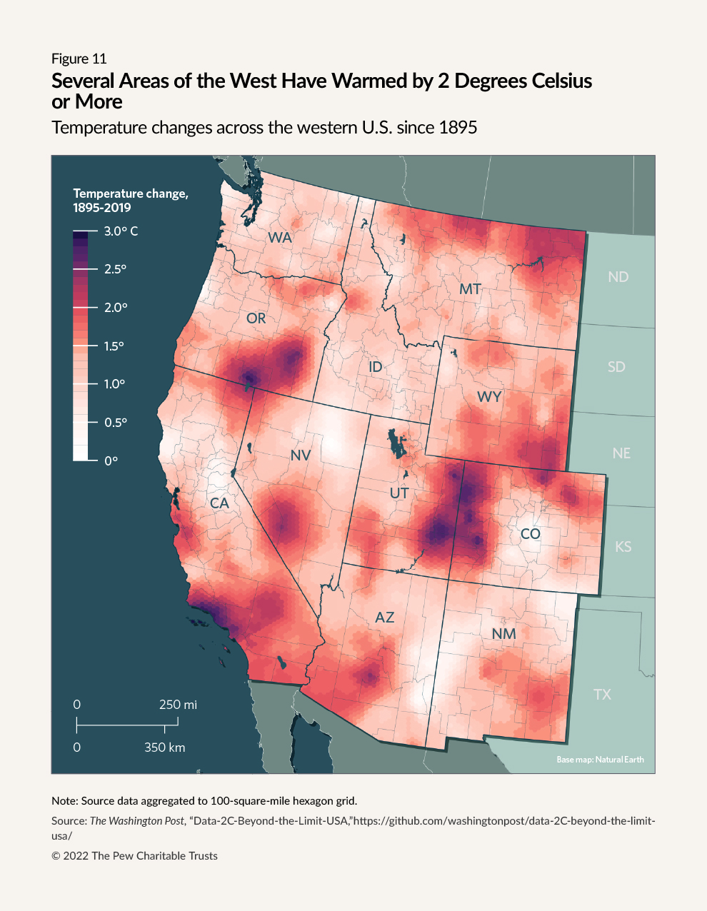
Climate plays a key role in plant ecology and in limiting or expanding the range of various wildlife species.109 Understanding how plants, landscapes, disease, and various ungulate species will respond to a warming climate is critical to conservation efforts. Some regions of the western U.S. have been more affected by climate change than others, including several that have already warmed by 2 degrees Celsius, resulting in drought, altered plant life cycles, wildfires, and other changes to ungulate habitat. (See Figure 11.)
One of the primary ways in which climate change may affect migratory ungulates is by shortening growing seasons and increasing the frequency and intensity of droughts, which can reduce the forage that animals access along their migratory routes.110 These effects may diminish the foraging benefits of migration to the point that animals will either experience increased mortality and lower reproduction or choose year-round residency rather than migration.111 This will be especially serious for temperature-sensitive species, such as moose, and species on the edge of their geographic range that have nowhere else to go for food as the plant abundance in their range declines.
Ungulate populations also will be affected by large-scale habitat alterations linked to climate change,112 such as the mountain pine beetle epidemic that has killed more than 1.5 million hectares of pine trees in northern Colorado and southern Wyoming.113
Relatedly, warming temperatures affect the timing of ungulate migrations, pushing them later into the fall, causing animals to spend more time on summer ranges, potentially altering prey-predator and other ecosystem dynamics, and putting hunting seasons out of sync with herd movements.114
Property boundaries
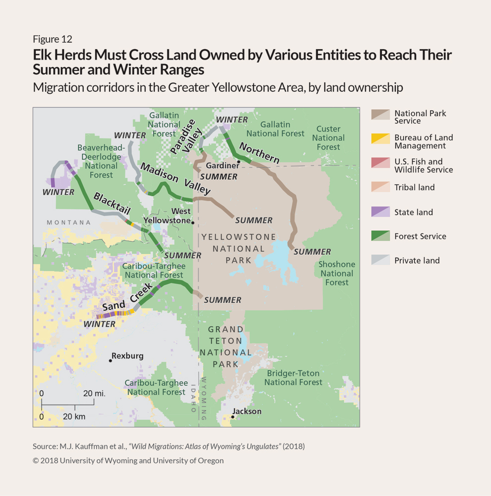
The western U.S. is characterized by a mix of land ownership patterns that include private, state, federal, and Tribal entities, and when ungulates migrate long distances, they often cross various administrative boundaries that mark distinct land uses for humans but are invisible to them. (See Figure 12.) Coordinating management of land uses that affect migrating animals across these jurisdictional borders can be a difficult and time-consuming process but is needed to ensure long-term conservation of migratory populations and the continuity of their routes.
For example, the thousands of elk that summer in Yellowstone National Park spend the other half of the year on private lands that have other uses, including ranching and farming, where the elk may cause problems, such as by grazing in areas meant for livestock and damaging crops.115 Similarly, pronghorn that summer in Grand Teton National Park migrate 100 miles each year to winter on federal lands where they must negotiate extensive energy development.116
Conserving migratory ungulates in the face of the many complex challenges that they face will require a diverse set of tools and programs aimed at retaining quality habitat and improving landscape connectivity. Fortunately, these efforts enjoy strong public support. For instance, in a 2022 survey, at least 80% of residents from each of several intermountain states and from across the political spectrum said they were strongly or somewhat in favor of wildlife migration conservation.117 This support represents an important opportunity for substantive action at the local, state, Tribal, and federal levels to implement evidence-based solutions to many of the threats facing migratory ungulates and their critical habitat.
Migration maps and assessment for planning
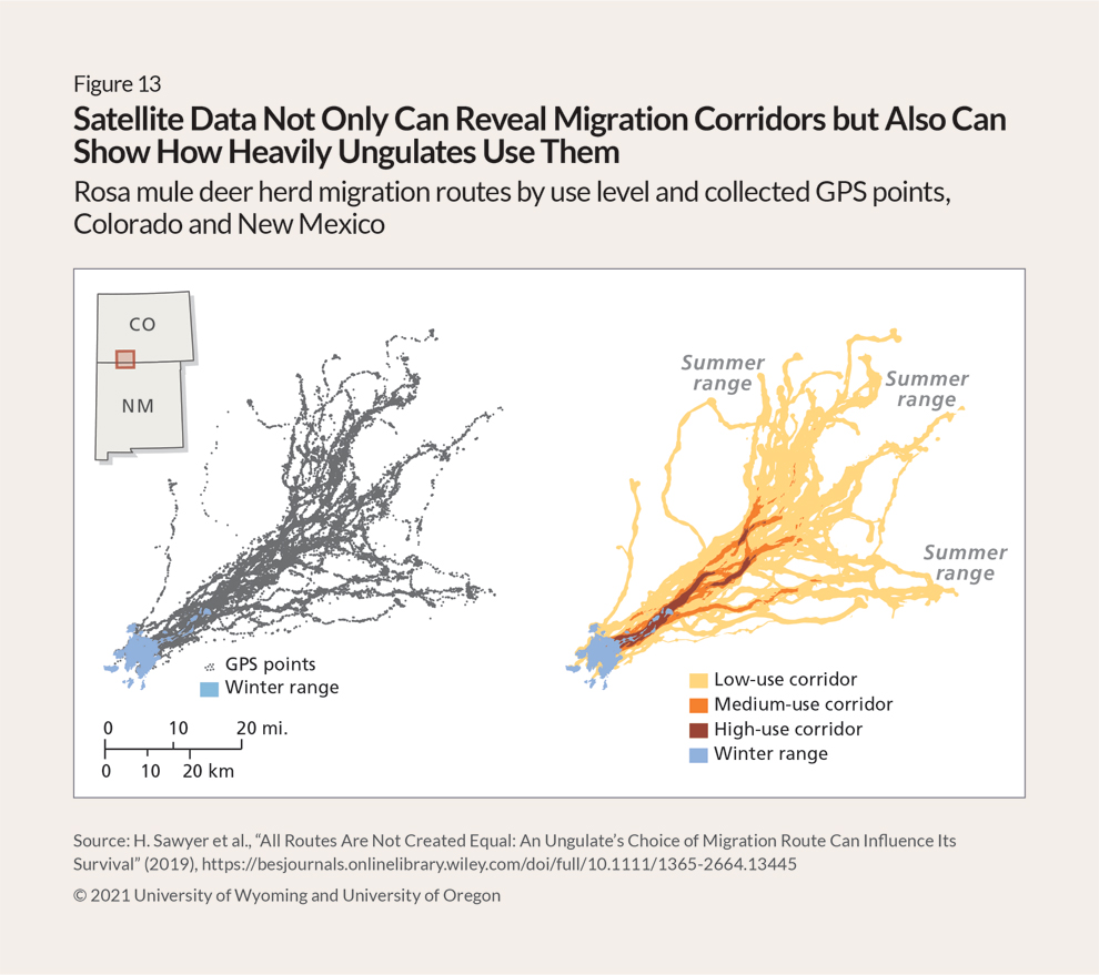
The widespread availability of movement data collected from GPS collars makes it possible to map migration corridors for entire herds, including stopover habitat, and to categorize routes as low, moderate, or high use. (See Figure 13.) Migration maps are easy to interpret and consider in land use planning.
Recent efforts in northeastern Montana and in areas of Wyoming around Yellowstone National Park provide examples of how transboundary ungulate migrations can be conserved through mapping and coordinated management across jurisdictions.118 In both cases, researchers or land managers began by mapping migration routes, noting pinch points and stopover habitat, across a patchwork of private working lands, public lands managed for various uses, Tribal lands, and a few protected areas.119 That data, in turn, gives land trusts and other stakeholders a tool for identifying areas where agreements with private landowners and administrative policies can be most effective in maintaining open ungulate migration routes.120
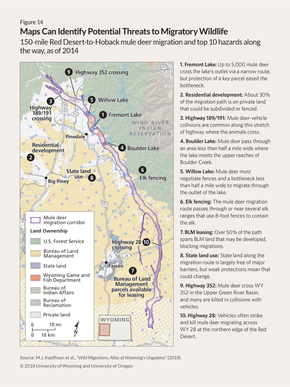
Researchers can also use this type of migration assessment to overlay maps showing potential threats, such as fences, roadways, and development. Policymakers, Tribes, and other interested parties can then identify potential solutions to the hazards and conflicts identified by the assessment.121 (See Figure 14.)
Such research and mapping initiatives—ideally undertaken as collaborations between states, Tribes, federal agencies, academia, and nonprofit organizations—are critical for conserving migration, but they require significant funding and other resources. In recent years, the U.S. Department of the Interior has provided support for collaborative research and mapping efforts by the U.S. Geological Survey as well as grants (administered by the National Fish and Wildlife Foundation) to states and Tribes for investigations of migration routes. However, many migrations remain unmapped, and more federal and state funding is needed to fully document the travels of ungulates in the western U.S.
Landowner identification and coordination
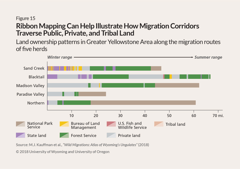
A first step in developing management or conservation priorities for a particular herd is to identify the full set of state and federal agencies, Tribes, private landowners, and conservation organizations—as well as their various administrative boundaries. However, for some migrations, especially those that span long distances and feature dozens of transboundary crossings, this can be a difficult task. One tool that can support this effort is “ribbon maps,” which clearly show all land ownership along a given migration route. (See Figure 15.)
Such holistic efforts that prioritize inclusiveness in conservation planning provide myriad benefits, including a better understanding of people’s intent or values, a sense of shared purpose, and a greater sense of how conservation efforts fit into a larger vision of protecting wildlife and other land uses. One model adopted in several western states involves ad hoc groups of landowners and other concerned people and organizations that meet regularly to discuss and act on conservation policy and funding needs. These collaborations have prompted widely supported policymaking efforts to identify and conserve ungulate migration corridors. Similarly, in Wyoming, the governor has created formal groups that assess known migration routes and consider whether the governor should designate them for conservation. Although these groups require significant time investments by members, they help ensure that proposed solutions are effectively designed to conserve migrating wildlife over the long term.
Fence removal and modification
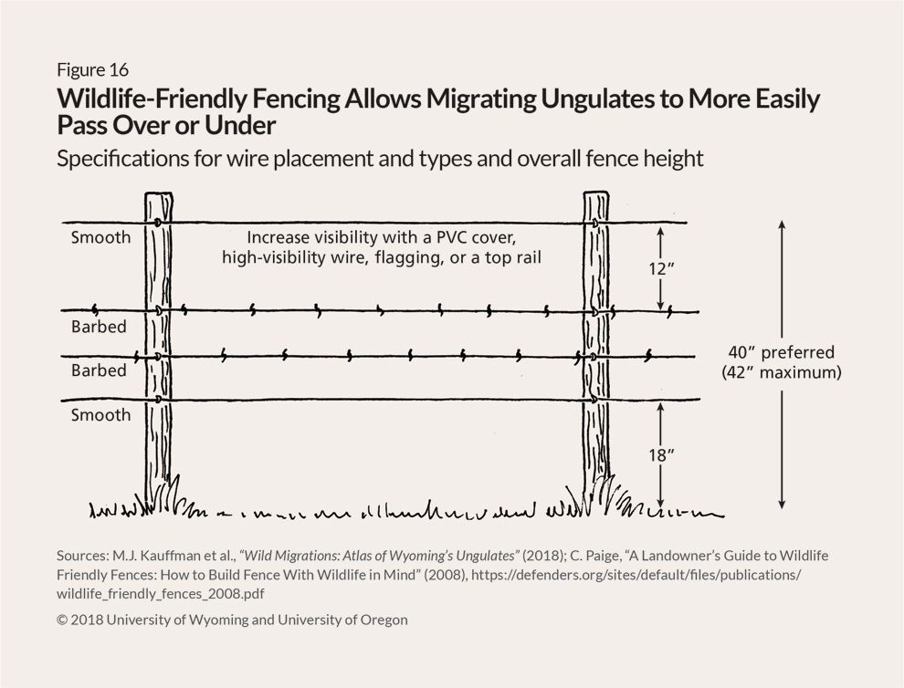
Removing fences or modifying their design can help reduce the risk of harm and improve the continuity of migration routes.122 Fence designs that accommodate ungulate movements are often referred to as “wildlife friendly” and have specific guidelines for the number, type, and height of wires. (See Figure 16.) Although wildlife-friendly fencing does make it easier for most ungulates to move about the landscape, it is not a panacea and can still be an impediment for animals in certain sex and age groups and during winter months when snowpack obstructs the space under a fence.123 Most western states have private or government-funded programs that help landowners modify fences to wildlife-friendly standards.
Wyoming and other western states encourage landowners to use wildlife-friendly fencing, which can take several forms depending on the type of livestock being contained, the wildlife species using the area, and other factors. In general, however, the ideal fence design includes a smooth bottom wire 18 inches above the ground, a smooth top wire no higher than 42 inches, no less than 12 inches of spacing between the top two wires, and very taut wires, which don’t tangle as easily as loose wires.
Virtual fencing technology is also an increasingly viable option for maintaining migration corridors while effectively containing domestic animals, such as cattle, within predetermined boundaries. These systems use GPS-enabled collars that deliver vibrations or gentle electrical shocks to domestic animals that venture outside those boundaries, effectively eliminating the need for physical fences and creating more open landscapes for wildlife to move through.
Roadway crossing structures
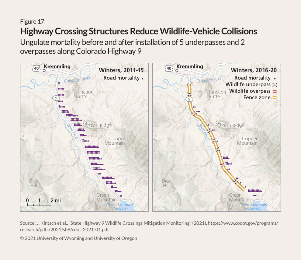
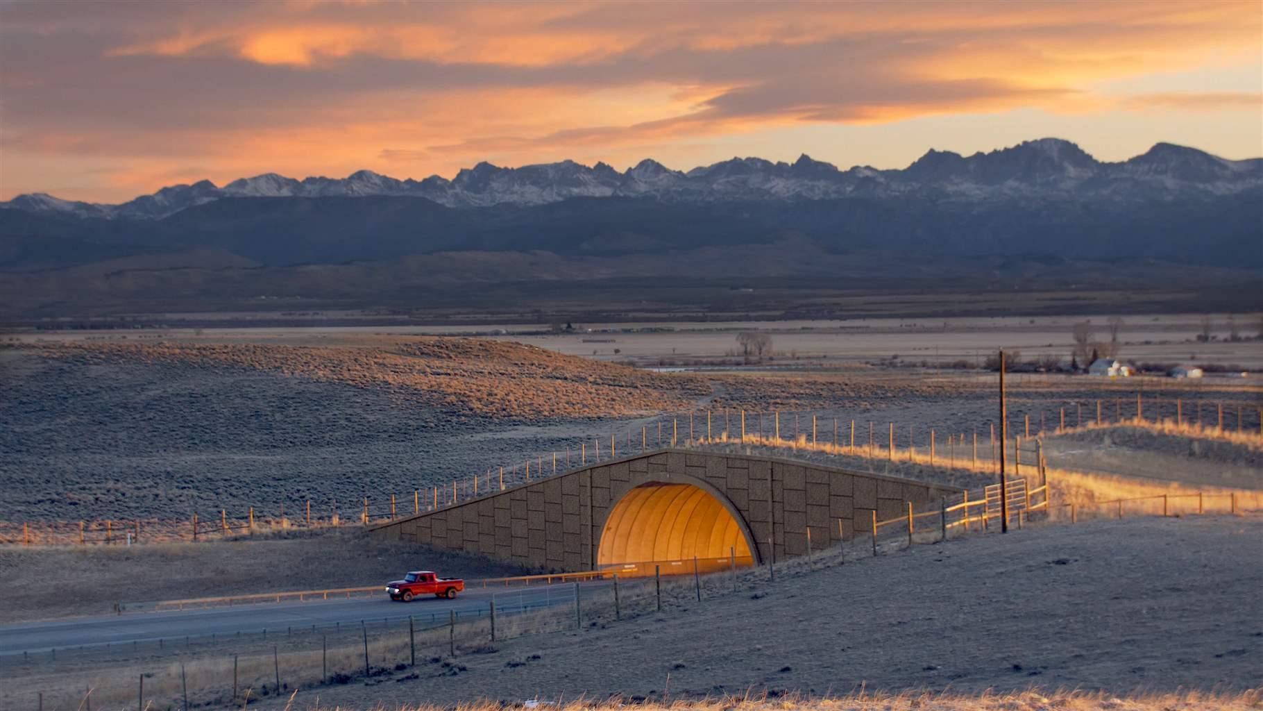
Crossing structures that allow animals to move safely under or over roadways have evolved in recent decades from basic concrete or steel culverts to sophisticated underpasses and overpasses. When properly sited in or near existing migration corridors, crossing structures can effectively reduce wildlife-vehicle collisions by more than 80%, improve motorist safety, and reduce the effects of habitat fragmentation on wildlife and ecosystems.124 (See Figure 17.)
These structures are most successful when gameproof fencing is installed adjacent to them and parallel to roadways to help guide animals toward the crossing.125 Their effectiveness can also be improved by minimizing nearby human activity and incorporating species-specific preferences.126 For example, pronghorn strongly prefer overpasses to underpasses.127
Although crossing structures have high construction costs, they often pay for themselves relatively quickly through savings associated with reduced collisions, which cost $9,086 per deer on average.128 For example, one study estimates that a $2 million overpass, completed in 2012 on U.S. Highway 191 in Wyoming, saves $570,000 annually in reduced collisions, surpassing its construction cost in only four years.129
And new federal and state funding opportunities for these structures are becoming available. The 2021 bipartisan infrastructure law includes a variety of new monies for wildlife crossings, including a dedicated $350 million competitive grants program.130 State legislatures are also increasingly active in funding wildlife crossings through a variety of mechanisms, including specialty license plates, mitigation programs, and general fund appropriations.
Conservation easements and private land incentives
Government agencies and nonprofit organizations such as land trusts and hunting conservation groups can maintain open habitat on private lands and working ranches by agreeing to conservation easements— voluntary, contractual agreements with private landowners—to ensure that specified lands will be maintained as open space. Landowners may donate an easement without compensation or choose to receive a financial benefit, typically tax breaks for donated land, cash payments for purchased easements, or a combination, and the initiating organization or agency assumes the right to monitor and enforce restrictions in the easement agreement. Most such easements are in perpetuity, but some preclude development without a permanent time restriction.
Conservation easements have helped protect ungulate migrations throughout the Intermountain West.131 Other tools, including wildlife occupancy agreements or habitat leases, can also be used to compensate landowners for providing quality wildlife habitat with or without an associated easement. For instance, Montana is developing a program to lease priority wildlife habitat areas for 30- or 40-year terms from private landowners for conservation purposes and, in some cases, for uses such as hunting, recreation, and livestock grazing or other agricultural functions.132
Additionally, some conservation agreements are structured to be active only during certain times of the year, such as while animals are migrating between seasonal habitats. In these instances, landowners may allow for certain fences to be temporarily laid down or removed or agree to move domestic livestock to pastures away from migration routes during the migration period.
Federal, state, and local entities will need to develop tools that foster new ideas and opportunities for collaboration among landowners and managers. For example, a U.S. Department of Agriculture initiative, launched as a pilot program in Wyoming in 2022, draws on several existing USDA programs, including the Grassland Conservation Reserve Program, Environmental Quality Incentives Program, Regional Conservation Partnership Program, and Agricultural Conservation Easement Program, to provide financial and technical assistance for landowners who want to conserve wildlife and migration corridors on their working lands.133 USDA plans to use lessons learned from the pilot to eventually expand the program across the West.
Smart energy and mineral development on federal lands
Federal agencies with mandates to manage public lands for multiple uses, such as the Bureau of Land Management (BLM) and U.S. Forest Service, collectively oversee more than 400 million acres in the 11 western states and Alaska.134 These lands serve as critical seasonal and migratory habitat for much of the region’s ungulate populations while also serving economic development, recreation, and other conservation interests.
These agencies have discretion over the placement of fossil and renewable energy development on federal lands. BLM and Forest Service land use plans, which identify suitable areas for these types of development and serve as important repositories for migration information, can be revised or amended to incorporate the best available science regarding thresholds and tolerances of ungulates and to apply various land use restrictions on known migration corridors and other crucial habitat. For instance, limiting the density of oil and gas well pads, timing construction work around key migration periods, and keeping aboveground extraction activity and infrastructure out of critical migration areas can all help maintain functional migrations.
States also can use their authority over permitting for energy projects to support conservation efforts. Colorado, for instance, recently changed the mission statement of its oil and gas commission to include consideration of human health and environmental stewardship and implemented new rules requiring the commission to identify ungulate migration routes and then consult with the state wildlife agency to develop plans to minimize the impacts of development on migrating wildlife.135
Similarly, although the General Mining Act of 1872 limits federal agencies’ control over the location of mines, more recent legislation—the Federal Land Policy and Management Act of 1976—empowers the BLM, which manages mining on federal lands, to halt or restrict “unnecessary or undue degradation” of those lands by regulating the timing of operations, disposal of waste, or siting of aboveground facilities, for example.136 However, the Mining Act also allows miners to “patent” or take ownership of their claim, in which case the land becomes private, and conflicts must be resolved as with any other private landowner.
Local and regional land use planning
The four fastest-growing states in the U.S. are also home to large populations of migrating wildlife. Utah and Idaho, for example, grew by 18.4% and 17.3%, respectively, between 2010 and 2020.137 Much of this growth has occurred in urban areas such as Salt Lake City and Boise, but smaller “gateway” cities and towns adjacent to scenic areas and public lands have experienced significant booms in housing demand in recent years, especially since the start of the COVID-19 pandemic.138
The location of new residential developments, associated road networks, and other intensive land uses, such as shopping malls and server farms, in previously rural areas often overlaps with important winter habitat for deer, elk, pronghorn, and other migratory species.139 Western counties and municipalities are grappling with how to accommodate this growth while maintaining the wildlife resources that are part of what attracts new residents and visitors. Comprehensive land use plans, often at the county level, offer community leaders a tool for managing future growth in ways that can reduce the impacts of urban and exurban development on critical corridors and other habitat. Several components of county or city planning processes, including zoning restrictions, open space acquisitions or easements, and transportation planning, can focus growth away from migration routes and other crucial habitat.
Conclusion
Thanks to evolving technology and emerging research, scientists, conservationists, policymakers, and other stakeholders are developing a fuller understanding of how migratory behavior plays a vital role in maintaining abundant and healthy ungulate populations, which in turn provide significant cultural, economic, and dietary benefits to humans. The science of wildlife migration has advanced at a rapid pace over the past decade, although much remains to be learned about the breadth of this phenomenon across the western U.S. Tens of thousands of data points now accumulate daily, continually adding to the body of knowledge about how and when deer, elk, pronghorn, and other large mammals move across landscapes.
This data provides the foundation for policy and management decisions at all levels of government that can best conserve migrating wildlife. By identifying the routes that animals use and the timing of their journeys, states, managers, Tribes, landowners, and other concerned parties can tailor management strategies to maintain ancient wildlife pathways.
Migrating wildlife faces diverse challenges. Land use trends in the West, particularly in rural areas, almost invariably result in habitat loss and fragmentation, and because migration routes tend to span many miles across multiple jurisdictions, stakeholders will need to employ a range of solutions rather than a single tool. Fortunately, a full toolbox already exists. Conserving a given migration might involve a bridge across a highway, an exclusion zone for new energy development, a county land use plan that incorporates wildlife movement areas, or one of the other approaches highlighted in this report.
The science is clear, and solutions exist. All that remains is for the various stakeholders to embrace those solutions. When deployed in tandem, science and action can provide a bright future for the migrating wildlife that are emblems—and economic drivers—of the American West.
